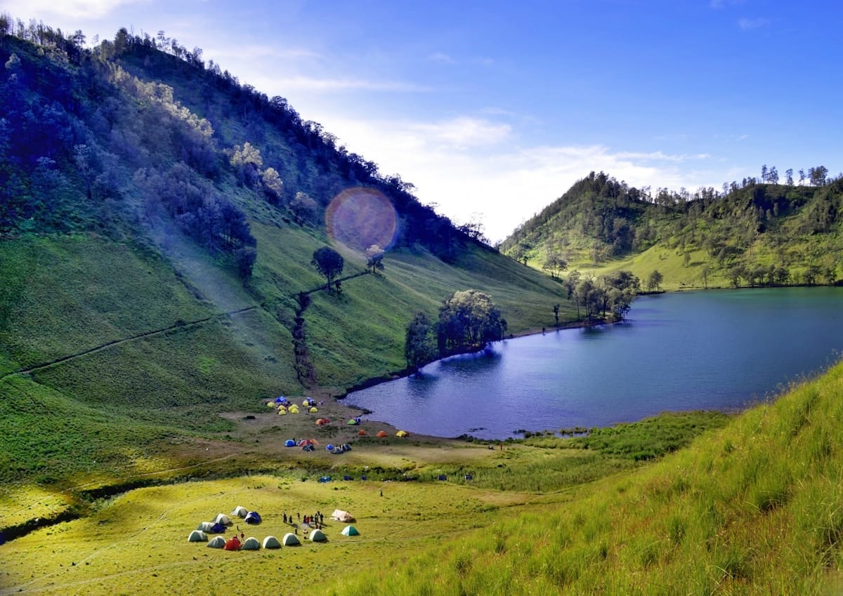
At 3,676 metres, Mount Semeru is the highest peak in Java and one of the most active volcanoes on an island that has no shortage of them. Its summit - called Mahameru, “Great Mountain” in Sanskrit - holds a sacred place in Hindu-Javanese cosmology: the abode of the gods, transported from India to anchor the island of Java when it was floating and unstable. Today it draws thousands of Indonesian trekkers annually and an increasing number of international visitors who come for the combination of volcanic drama, the lake camp at Ranu Kumbolo, and the genuine physical challenge of standing on Java’s roof.
The Route: Overview
The standard Semeru trek takes 2 days and 1 night, though some hikers extend to 3 days for a more relaxed pace and better acclimatisation. The trailhead is at Ranu Pani (2,100m), a small village in the Tengger highlands reached by vehicle from Malang. All hikers must register at the Ranu Pani ranger post before setting out.
Day 1: Ranu Pani → Ranu Kumbolo (13 km, 4–5 hours) The trail begins through savanna-like highland meadows and short forest sections before the gradient steepens into switchbacks climbing to Ranu Kumbolo. The route passes Ranu Regulo lake (good for a break) before the final ascent to the crater lake. Arrive at Ranu Kumbolo by early afternoon to secure a good campsite and rest before the summit attempt.
Day 2: Ranu Kumbolo → Mahameru Summit → Descent to Ranu Pani Wake at midnight to 1am. Summit attempts begin in darkness to reach the crater rim at sunrise, before volcanic gas emissions increase with the heat of the day. From camp it’s roughly 6–7 hours to the summit and 4–5 hours down. The ascent from Kalimati camp (2,700m, last water point) to Mahameru covers 976 metres of altitude gain on steep, loose volcanic scree. Expect to be back in Ranu Pani by late afternoon.
Getting to the Trailhead
Ranu Pani is reached from Malang, the main city on the approach. Malang is served by trains from Surabaya (90 minutes, from IDR 30,000) and Yogyakarta (4–5 hours). From Malang city, minibuses run to Tumpang market, and from Tumpang, jeeps (IDR 350,000–500,000 return, shared or private) make the 1.5-hour drive up winding highland roads to Ranu Pani.
Most trekkers stay one night in Malang or the highland village of Gubugklakah (closer to the trailhead, guesthouses from IDR 150,000) before starting the trail.
Ranu Kumbolo: The Lake Camp
Ranu Kumbolo at 2,400m is the emotional centrepiece of the Semeru experience. The volcanic crater lake - roughly 1.5 km across - sits in a bowl of steep green hills. On clear evenings the water turns gold at sunset, and on still mornings it reflects the surrounding landscape perfectly. The campsite on the southwestern shore accommodates hundreds of tents; weekends and Indonesian public holidays see it packed with domestic trekkers. Midweek visits are considerably quieter.
The lake is considered sacred by the Tengger people, the Hindu-majority community of the Bromo-Semeru highlands. Swimming is not permitted. The Tengger trace their ancestry to the kingdoms of pre-Islamic Java, and Semeru features in their creation mythology - the mountain is believed to be a fragment of Mount Meru from the Indian subcontinent, dropped here to pin Java in place.
Camp logistics: Temperatures at Ranu Kumbolo drop to 5–10°C at night and occasionally below freezing. Pack a warm sleeping bag (rated to at least 0°C), down jacket, gloves, and a thermal layer. Cooking is permitted at the campsites; most trekkers bring instant noodles and rice from Malang. Filtered water is available from the lake (boil or treat before drinking). Porters can be hired from Ranu Pani at IDR 200,000–350,000 (USD 12–21) per day.
The Summit: Mahameru (3,676m)
From Ranu Kumbolo, the trail continues south over the Oro-Oro Ombo meadow - covered in invasive purple Verbena brasiliensis flowers that have colonised the hillside - before ascending steeply through Cemoro Kandang forest to Kalimati camp at 2,700m, the last flat ground before the summit zone.
The final push from Kalimati to the summit crater covers approximately 900 metres of altitude gain on loose volcanic scree and ash. Every 10 steps forward involves sliding back 3–4 steps on the steep slope. Most trekkers find this section takes 3.5–4 hours at an honest pace. Trekking poles are invaluable.
The crater at the top is active. Jonggring Saloka - the summit crater - vents sulfuric gas and occasionally launches small rocks. The park restricts lingering near the crater rim, and all guides carry emergency protocols for sudden eruption escalation. Follow your guide’s instructions without question in the summit zone.
Standing on Mahameru at sunrise, with cloud below you and the Bromo caldera visible to the northwest, is an experience that earns its difficulty. Java stretches to every horizon.
Operators and Guides
Since stricter post-2022 regulations, all summit-bound trekkers must use a TNBTS-registered guide. Several reputable operators organise complete packages including Malang pickup, transport to Ranu Pani, accommodation, guide, and return:
- Semeru Trekking (Malang) - 2-day summit package from IDR 1,200,000–1,800,000 (USD 74–110) per person sharing, registered guides, tent and sleeping bag rental included
- Bromo Semeru Adventure (Tumpang) - strong reputation, maximum group size 8 per guide, approximately IDR 1,500,000 (USD 92) per person; English-speaking guides available
- Jawa Outdoor (Malang) - private guided treks IDR 3,500,000–5,000,000 (USD 215–307) for groups of 2–4, includes photographer guide
Independent trekking (without a registered guide) on the summit route is currently not permitted following the 2022 disaster in which 22 people died during an eruption. TNBTS rangers check guide credentials at Kalimati. For all-inclusive Semeru trek packages with transport, guides, and camping gear, browse options on GetYourGuide.
Permits and Regulations
- SIMAKSI permit: Book online at the official TNBTS system before your trek. Daily trekker numbers are capped. International hiker fee: IDR 297,000 (USD 18) per day as of 2026.
- Registration at Ranu Pani: Mandatory on arrival. Bring passport or KTP.
- Guide requirement: Mandatory for summit route. Your guide must carry their TNBTS registration card.
- Volcano alert level check: Monitor Magma Indonesia (magma.esdm.go.id) for current Semeru activity level. Treks above 2,400m are suspended at Alert Level 3 and above.
Acclimatisation Tips
Semeru’s summit is high enough to cause altitude sickness in unacclimatised hikers. Symptoms - headache, nausea, loss of appetite - typically appear above 2,500m. If you have time, spending a night at 1,500–2,000m (the Malang area sits at 450m; the Tengger highland villages around 1,800m) before the trek reduces the risk considerably. Eat light on the summit day, drink 3–4 litres of water, and descend immediately if symptoms worsen rather than trying to push through.
Best Season
May to October (dry season) is the best time for Semeru. Clear skies, firm trail conditions, and reliable summit views. June, July, and August are the peak months for Indonesian trekkers and can be crowded at Ranu Kumbolo on weekends. April and October offer the best balance of good weather and manageable crowds. Avoid the wet season (November–March) - the scree becomes treacherous mud, visibility is poor, and the summit is often cloud-locked.